Data Analysis

Proximidade

2020-06-18T01:14:55+00:00

In 2012, Cemig started the development of the Research and Development (R&D) project called “INTEGRATED INTELLIGENT SYSTEM WITH WEB AND MOBILE TECHNOLOGY FOR EMERGENCY MANAGEMENT”, in partnership with FAPEMIG and UNIFAL and having Venidera as one of the main executors. The Project, completed in 2016, aimed to develop specialist systems to assist decision-making in emergency situations involving dams and reservoirs. Thus was born the inspiration of the “Proximidade” Platform, a system called the “Georeferenced Support System for the Operation Command System”: the SGA-SCO. At the time, a WEB system was created to support the management of contingency plans for emergency situations and communication with interested parties. The main functionalities were to assist civil defense agencies in mapping risk areas, creating escape plans, gathering information, resources and points of interest that are useful in the process of managing emergencies in disasters, in addition to issuing warning signs .

Expanding the scope of the relationship with communities program, Cemig in partnership with Venidera sought to develop an application with the objective of being yet another channel of information for populations influenced by the variation of river levels. Thus, in 2018, the SGA-SCO was used as a basis for the development of the Proximity Platform, which incorporated operating data from Cemig’s reservoirs to the platform. Proximidade also allows a more effective communication with the community through georeferenced registration fo the inhabitants themselves through the mobile application. Through the WEB platform it is still possible to view and print maps at different scales and types, such as satellite photo, street guide and terrain map, in addition to sending alerts to selected areas. Regarding the information that may compose the mappings, we highlight:

  • Geographical points related to inhabitants for counting and defining specifications for the evacuation of risk areas;
  • Geographic points related to resources such as vehicles, shelters, hospitals, etc;
  • Risk areas at different degrees of probability and risk severity;
  • Analysis of areas in relation to variations in relief and elevation and distances;
  • Escape routes for each mapped risk area.

The “Proximidade” Platform is, therefore, a powerful web tool to support civil defense bodies and, especially, to COMPDECs (Municipal Coordination for Civil Protection and Defense), which are the municipal bodies responsible for the execution, coordination and mobilization of all actions of civil defense in the municipalities. Basically, all information and planning performed at Proximidade can be printed at any time, preferably, before disastrous events, given the need for computer equipment and services such as electricity and internet are available. In this way, the municipality can build and update its Contingency and Response Plans and leave them ready for use whenever needed. Specially when dealing with disasters. Still, the mapped information can still be used for training and simulations, facilitating the work of management and assessment of risk and disaster planning. It is also worth mentioning that the mapping information can be easily updated so that it is possible to maintain consistent supporting documentation for use whenever the Operations Command System is activated.

Bellow is a tutorial video that illustrates how the “Proximidade” Platform works.

For privacy reasons YouTube needs your permission to be loaded.

I Accept

LINC Web

2018-11-14T23:01:28+00:00

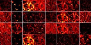
Venidera has been developing for a while the user interface and the database for the LINC project (http://iefrd.com/linc.html). This system aims to be a portal for the conservationists to upload pictures taken from lions and submit them to a facial recognition system (which is also a part of the LINC project) which runs on a dedicated cloud server.

This front-end was developed using state-of-the art HTML5 approach in order to achieve an optimal user experience with considerations that guarantee the same user experience even under poor internet connections (what usually happens in the African savannah).

Recently, the LINC Web has been recognized as the official lion database of Kenia.

IRIS (2016-2020)

2018-11-14T22:56:02+00:00

The IRIS project aims to address questions related to the massive penetration of intermittent power sources (such as wind and solar) into the Brazilian grid, covering aspects ranging from electrical and operational issues to regulatory improvements to cope with this new scenario.

The IRIS project counts with the support of federal agencies and institutes such as EPE (governmental research company), ANEEL (local regulator) and ONS (local ISO).

BID-MONITOR (2015-2017)

2018-04-12T13:45:28+00:00
The BID-MONITOR was an R&D project sponsored by Elektro, Santa Elina and Aratu, whose goal was to develop a system able to automatically capture and monitor different sources of information (from the web) to, thus, monitor the behavior of the data relevant to the participation of a small generator or a distribution company in electricity auctions. For this purpose, an early warning system was developed to provide early support to decision makers so that they are now able to more accurately determine when and how much electricity to trade.

CEMIG R&D (2013-2015)

2018-04-12T13:30:24+00:00

As the main executor, Venidera led this project whose main objective was to develop new models and technologies to improve the diagnosis of dam failures and also the response time in cases of critical events. With this, innovative models were developed to monitor the state of CEMIG dams and two decision support systems were developed: an internal tool for dam assessment and emergency support and an external tool for emergency preparedness. Many extraordinary results have already been obtained and published. Among them, one paper in the ICFM6 “(6th INTERNATIONAL CONFERENCE ON FLOOD MANAGEMENT)“, one paper in the XXXI SNGB “(XXXI National Seminar on Large Dams)” and one other paper in the DW2018 “(Dam World 2018)“.

PPTE R&D (2012-2015)

2018-04-12T13:08:45+00:00

Venidera participated in this R&D project to help Unicamp (main research team) organize and make available all the data necessary for its researchers to conduct their individual investigations. In addition, a decision support system was built to assist PPTE in detecting regions in its transmission systems that might require more attention and to identify where it might be necessary to construct natural barriers to minimize the effects of gusts and strong winds in its lines. The developed computational tool, which was materialized in two mobile applications and a web portal, gathered all the results obtained in this project and, as an additional result, was also able to alert the employees of the PPTE with a 24 hour advance or more with respect to a possible severe storm that could affect its transmission lines.

CTEEP R&D (2011-2012)

2016-08-24T22:58:36+00:00

Venidera participated in the project helping main executors (Unicamp and Prinsis) to build a model and a decision support system to help CTEEP improve the reliability of its transmission system. Moreover, one other decision support system was built to help CTEEP track down and predictively act in order to minimize transmission line failures. This system is being used by CTEEP since then.

AES Tietê R&D (2010-2012)

2016-11-17T14:07:20+00:00

Beginning in 2010, Venidera worked together with a research team from the Faculty of Civil Engineering (Unicamp) to develop a model and a decision support systems for optimizing the dispatch decisions of turning on and off individual generators with the goal of maximizing production (and, consequently, reducing the water consumption). Results were outstanding and also published in many websites and journals, such as:

ANEEL Strategic Call R&D (2010-2012)

2014-09-08T17:03:00+00:00

While Ph.D. researchers, Marcos Leone Filho (Venidera’s co-founder), André Toscano (Venidera’s co-founder) and Makoto Kadowaki (Venidera’s team member) actively contributed in this project helping to build a non-linear deterministic optimization model for the Brazilian National Interconnected System. The goal of this model was to provide individualized optimization dispatch decisions for planning the Brazilian generation system. Moreover, parallel computing and a computer cluster were used to cope with the huge processing times of this model.

Go to Top